Japan's Paper Empire: Mapping the Environmental Effects of Japanese-led Paper Industrialization in Manchuria
Chad Westra, History
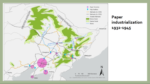
My project uses digital-spatial methods to explore the ecological ramifications of Japan’s development of the industrial pulp and paper industries in northeastern China during the Manuchukuo period. From 1931-1945, Japan grew northeastern China’s paper industry to a total of forty-three facilities, incorporating the region into a transnational resource regime that linked pulpwood from China’s old-growth forests to Japan’s largest paper companies. Using GIS tools, such as georeferenced forest maps and a database of factory locations, I plot the expansion of paper and pulp factories alongside the region’s remaining old-growth forests. Though Japanese-led forestry operations in Manchuria initially emphasized sustainable management, the policy of industrial boom pursued during the war contributed to a depletion of old-growth forests, a shift toward preferred species forest composition, and an increase in industrial pollution. It also transformed the northeast into postwar China’s most important paper manufacturing region. My presentation will focus on the maps I created in ArcGIS for this paper, the methodology of using georeferencing for historical maps, and reflections on the prospects and problems inherent in using mapping technologies for historical studies.