
Proceedings of the Seventh Annual UW GIS Symposium: Potential Location Assessment of Current and Estuarine Surveys (PLACES) for the National Oceanic and Atmospheric Administration (NOAA)

Proceedings of the Seventh Annual UW GIS Symposium
Potential Location Assessment of Current and Estuarine Surveys (PLACES) for the National Oceanic and Atmospheric Administration (NOAA)
    • Notifications
    • Privacy
  • Project HomeUniversity of Washington GIS Symposiums
  • Projects
  • Learn more about Manifold

Notes

Show the following:

  • Annotations
  • Resources
Search within:

Adjust appearance:

  • font
    Font style
  • color scheme
  • Margins
table of contents
  1. Title Page
  2. Contributors
  3. Contents
  4. Preface
  5. Keynote
  6. Short Talks
    1. Farewell Victoria: Quantifying the Value of Foreign Names
    2. Potential Location Assessment of Current and Estuarine Surveys (PLACES) for the National Oceanic and Atmospheric Administration (NOAA)
    3. Temporal Tensions in Digital Story Mapping for Housing Justice: Rethinking Time and Technology in Community-Based Design
    4. Reducing Customs and Border Protection's 100-Mile Enforcement Zone in Washington State
    5. Comparing Rail Transit in Seattle, WA and Singapore
    6. Habit Fragmentation Via Roads in King County
    7. Changes to the Shoreline of Mud Bay, Bellingham, Washington

Potential Location Assessment of Current and Estuarine Surveys (PLACES) for the National Oceanic and Atmospheric Administration (NOAA)

Caitlin Guerin, Nick Hanson, and Austin Hackett, UW Professional and Continuing Education

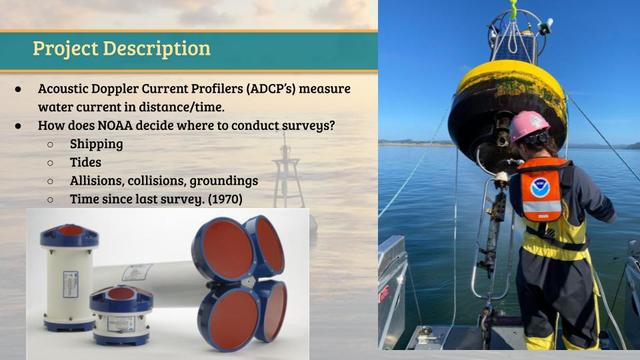
Ocean and river current surveys have been conducted since the mid 1800s. How the National Oceanic and Atmospheric Administration (NOAA) decides where to conduct these surveys is what our GIS tool will accomplish. The most recent method of prioritization, the "Potential Location Assessment of Current and Estuarine Surveys'' (PLACES) is from 2014. This method utilized a combination of spatial analysis software, R, and fuzzy logic to produce an ordered list of locations. We are creating a new GIS based tool to improve this method. We will take the average value of each parameter per polygon, rasterize the data, reclassify, and use a weighted overlay. We will conduct this process in model builder in order to easily change the weight of certain parameters to see its effects on the ranking of locations and to easily share the process with NOAA. It is important to furnish NOAA with the best, most up to date metadata information that is used to choose the best locations to provide commercial shipping, fisherman, and recreational users with the most accurate and up to date current predictions that NOAA can provide. Overall, this tool will benefit NOAA and its stakeholders, create a quicker process for determining locations in need of currents analyses and maximize the resources that NOAA has to offer.

A powerpoint slide featuring a description of the NOAA PLACES project, which used Acoustic Doppler Current Profilers.

Annotate

Next Chapter
Temporal Tensions in Digital Story Mapping for Housing Justice: Rethinking Time and Technology in Community-Based Design
PreviousNext
Powered by Manifold Scholarship. Learn more at
Opens in new tab or windowmanifoldapp.org