
Proceedings of the Seventh Annual UW GIS Symposium: Changes to the Shoreline of Mud Bay, Bellingham, Washington

Proceedings of the Seventh Annual UW GIS Symposium
Changes to the Shoreline of Mud Bay, Bellingham, Washington
    • Notifications
    • Privacy
  • Project HomeUniversity of Washington GIS Symposiums
  • Projects
  • Learn more about Manifold

Notes

Show the following:

  • Annotations
  • Resources
Search within:

Adjust appearance:

  • font
    Font style
  • color scheme
  • Margins
table of contents
  1. Title Page
  2. Contributors
  3. Contents
  4. Preface
  5. Keynote
  6. Short Talks
    1. Farewell Victoria: Quantifying the Value of Foreign Names
    2. Potential Location Assessment of Current and Estuarine Surveys (PLACES) for the National Oceanic and Atmospheric Administration (NOAA)
    3. Temporal Tensions in Digital Story Mapping for Housing Justice: Rethinking Time and Technology in Community-Based Design
    4. Reducing Customs and Border Protection's 100-Mile Enforcement Zone in Washington State
    5. Comparing Rail Transit in Seattle, WA and Singapore
    6. Habit Fragmentation Via Roads in King County
    7. Changes to the Shoreline of Mud Bay, Bellingham, Washington

Changes to the Shoreline of Mud Bay, Bellingham, Washington

Ruby Leotta, Earth and Space Sciences

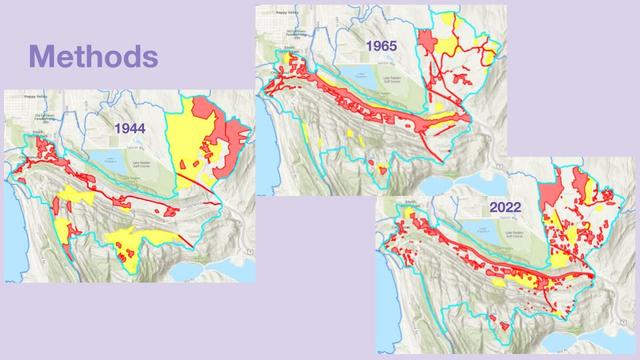
The land use in and around Mud Bay, South of Bellingham, has changed over time, including logging, mining and quarrying in the late 1800s to early 1900s, as well as railroad and interstate construction in the 1920s and 1960s. Prior work has shown that the bay is filling with sediment at a rate greater than the projected sea level rise. In this project, we want to document the timing of major land-use change and determine whether the shoreline of the enclosed bay has changed over time. In order to precisely document our data, we georeference historic maps, aerial photographs and satellite images with geographic information system (GIS) software to define the shoreline and map land-use and shoreline changes over the decades. We compare the shoreline and land-use changes correlating with previously extracted sediment cores. With this research, we aim to learn about the competing influences of sea level rise and land-use change on the position of the shoreline and sedimentation in Mud Bay. Conducting this research on Mud Bay will also help us learn how to apply these methods and information to other similar landforms around the world.

A slide titled Methods featuring three maps of the Mud Bay region from three different years, with color coded regions to indicate different types of land cover.

Annotate

Previous
Powered by Manifold Scholarship. Learn more at
Opens in new tab or windowmanifoldapp.org