Proceedings of the Seventh Annual UW GIS Symposium: Keynote

Proceedings of the Seventh Annual UW GIS Symposium
Keynote
    • Notifications
    • Privacy
  • Project HomeUniversity of Washington GIS Symposiums
  • Projects
  • Learn more about Manifold

Notes

Show the following:

  • Annotations
  • Resources
Search within:

Adjust appearance:

  • font
    Font style
  • color scheme
  • Margins
table of contents
  1. Title Page
  2. Contributors
  3. Contents
  4. Preface
  5. Keynote
  6. Short Talks
    1. Farewell Victoria: Quantifying the Value of Foreign Names
    2. Potential Location Assessment of Current and Estuarine Surveys (PLACES) for the National Oceanic and Atmospheric Administration (NOAA)
    3. Temporal Tensions in Digital Story Mapping for Housing Justice: Rethinking Time and Technology in Community-Based Design
    4. Reducing Customs and Border Protection's 100-Mile Enforcement Zone in Washington State
    5. Comparing Rail Transit in Seattle, WA and Singapore
    6. Habit Fragmentation Via Roads in King County
    7. Changes to the Shoreline of Mud Bay, Bellingham, Washington

Keynote Address

Climate Mapping for a Resilient Washington

Matthew Rogers, Climate Impacts Group at University of Washington Seattle.

With both current and impending climate change, it’s imperative for local government in Washington to state to learn and adapt to the projected impacts like reduced snowpack and increased extreme precipitation. Relying on the internal expertise of the Climate Impacts Group (CIG) at the University of Washington and feedback from multiple state agencies and partners, CIG has compiled and curated the best available climate change projection data into a web application. This application allows local governments and planners to explore and download projected climate change impact data geographically, temporally, and under multiple different future greenhouse gas emission scenarios. In this talk, I will outline the problem that this web application addresses, the process for creating the tool, and demonstrate several of the novel functions that set it apart from other tools like it.

Matthew Rogers is a research scientist with the Climate Impacts Group at the University of Washington, specializing in the latest data and data science methods for analyzing climate projection data. He holds both a B.S. in Atmospheric Science from the University of Washington and M.S. in Meteorology from the University of Oklahoma.

Link to the web application: https://cig.uw.edu/resources/analysis-tools/climate-mapping-for-a-resilient-washington/
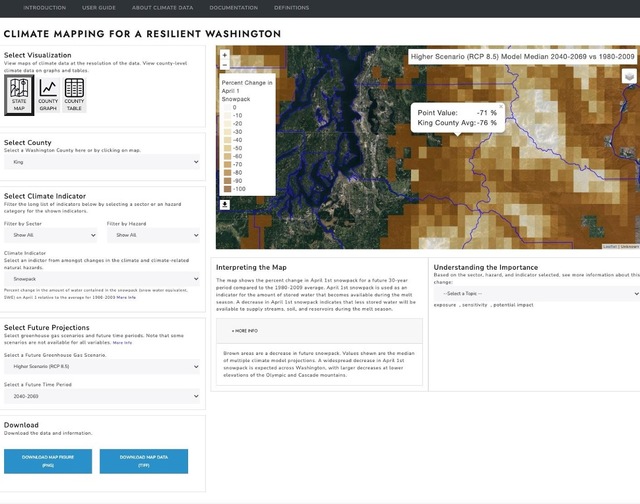
A screenshot of the web application developed by Climate Impacts Group, which allows local governments and planners to explore and download projected climate change impact data geographically, temporally, and under multiple different future greenhouse gas emission scenarios.

Annotate

Next Chapter
Short Talks
PreviousNext
Powered by Manifold Scholarship. Learn more at
Opens in new tab or windowmanifoldapp.org