Assessing Environmental and Social Vulnerabilities to Natural Hazards in Coastal Communities: A Case Study of the U.S. Gulf Coast
Chi-Ying Huang, Civil and Environmental Engineering
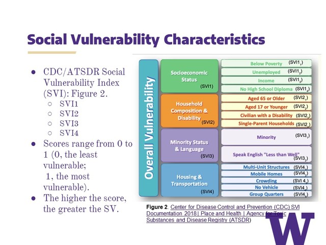
Risk management in the context of natural hazards encompasses the assessment of hazards, vulnerability, and exposure. This research focuses on exploring the characteristics of environmental vulnerabilities within communities susceptible to coastal flooding, hurricanes from storm surges, and extreme weather events, specifically targeting the Gulf Coast of the United States. The study aims to identify areas of high risk, including flooding, hurricane storm surges, and sea-level rise, in coastal counties of Mississippi and Alabama at the Census tract level. Using ArcGIS Pro software, I will map social vulnerability factors such as socioeconomic status, household composition and disability, and minority status and language skills. Environmental vulnerability data, including flooding risk and inundation, will be sourced from Federal Emergency Management Agency (FEME), National Oceanic and Atmospheric Administration (NOAA), and U.S. Geological Survey (USGS). Social vulnerability data will be obtained from the Centers for Disease Control and Prevention (CDC) and the Agency for Toxic Substances and Disease Registry (ATSDR). Through spatial analysis using ArcGIS Pro, I will visualize and overlay environmental and social vulnerability data, facilitating the identification of areas with high combined vulnerability and highlighting potential hotspots for targeted interventions. This project aims to enhance the understanding of how environmental and social factors intersect and exacerbate vulnerabilities in coastal communities. The findings will be useful to local policymakers, stakeholders, and community leaders, contributing to the fields of environmental justice, coastal resilience, and sustainability.