
Proceedings of the Eighth Annual UW GIS Symposium: Mobile Mapping System for 3D Road Asset Inventory of the Rural Road Network in Thailand

Proceedings of the Eighth Annual UW GIS Symposium
Mobile Mapping System for 3D Road Asset Inventory of the Rural Road Network in Thailand
    • Notifications
    • Privacy
  • Project HomeUniversity of Washington GIS Symposiums
  • Projects
  • Learn more about Manifold

Notes

Show the following:

  • Annotations
  • Resources
Search within:

Adjust appearance:

  • font
    Font style
  • color scheme
  • Margins
table of contents
  1. Title Page
  2. Contributors
  3. Contents
  4. Preface
  5. Keynote
  6. Lightning Talks
    1. Unlocked Maps: A Web-Based Map for Visualizing the Real-Time Accessibility of Urban Rail Transit Stations
    2. VoxLens: Making Geospatial Data Visualizations Accessible to Blind and Low-Vision Users
    3. The Folk Linguistic Online Mapping tool (FLOM) - Challenges, Opportunities and Next Steps
    4. Mobile Mapping System for 3D Road Asset Inventory of the Rural Road Network in Thailand
    5. Bird Friendly Campus: Analyzing Bird Window Collision Data
    6. Co-Seismic Landslides and Reactivations
    7. Assessing Environmental and Social Vulnerabilities to Natural Hazards in Coastal Communities: A Case Study of the U.S. Gulf Coast
    8. Using Location Data From Smartphones to Time a Small Marathon
    9. Environmental Justice in LA County Through the Lens of Remote Sensing

Mobile Mapping System for 3D Road Asset Inventory of the Rural Road Network in Thailand

Nutvara Jantarathaneewat, Civil and Environmental Engineering

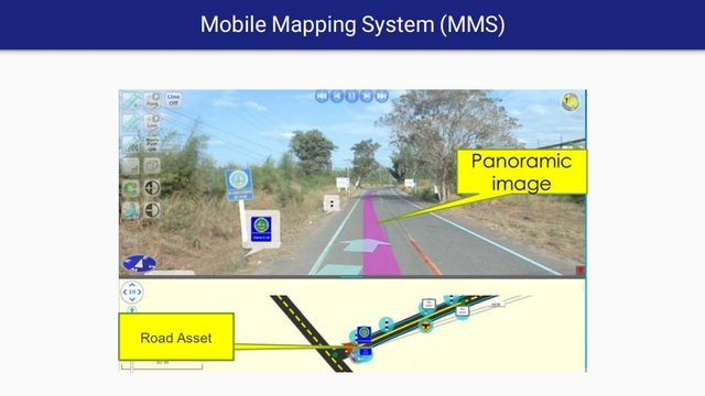
The Department of Rural Roads (DRR) of Thailand has been using the Mobile Mapping System (MMS) in road surveying since 2014, which can reduce the time and number of surveyors. Currently, DRR can acquire more than 47,000 km of road asset inventory data, which is required to be updated every year. This study develops a prototype surveying device by integrating a high-precision LiDAR data sensor into existing MMS devices. Thus, besides the survey photo, this device also provides a precise location along with the photo. Survey data is displayed in point cloud format through online applications. For the accuracy of the prototype equipment, the result shows that this device can provide accuracy of positioning equivalent to a map resolution of 1:500, which ensures the quality of locating the rural road assets. For future development, the road assets can be located automatically by using artificial intelligence to detect types of an asset on survey photos. Hence, the department is able to prepare asset data and monitor usage conditions as appropriate according to engineering principles.

Mobile Mapping System

Annotate

Next Chapter
Co-Seismic Landslides and Reactivations
PreviousNext
Symposiums
Powered by Manifold Scholarship. Learn more at
Opens in new tab or windowmanifoldapp.org